
1940s

 A map depicting the Italian households within West Philadelphia according to the 1940 census, showing they were mostly situated in Morris Park, Haddington, and Cathedral Park.

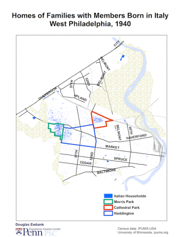
South Philadelphia is well-known for its population of Italian immigrants.  However, 6,600 Italians immigrants lived in West Philadelphia in 1940, second only to Russian-born Jews. They settled in two areas.  Half lived in Morris Park and the neighboring areas of Haddington west of 60th St. and southern Overbrook west of Wynnewood Rd. One-fourth of adults in this area were born in Italy; 40% were either born in Italy or had a parent born there.


The other area was in Cathedral Park which was the home to another one-fifth of West Philadelphia’s Italians.  That neighborhood was split into two sections on opposite sides of Cathedral Cemetery.  South of the cemetery was predominately Irish.  North of the cemetery was predominately Italian.  Between the cemetery and Lancaster Ave., 23% of adults were born in Italy—37% were either born there or had a parent who was.


This photo shows the excavation of the Market Street tunnel at 36th Street. Tunnel digging had harmful effects for the surrounding blocks, in this case a majority-African American neighborhood known locally as the Black Bottom. 

This diagram shows the original plan for construction of the rapid transit/subway tunnel. 

This photo shows the El near 32nd Street on the eve of renewed tunneling of the West Philadelphia integrated rapid transit and subway system, which had been halted during the Great Depression and Second World War.

Some 200 gardens measuring 25 by 25 feet are laid out across this tract (formerly Passon Field) for Victory Gardens. 

During the Second War World, the athletic venue once called Passon Field was deployed as Victory Gardens. The view is east toward 48th Street, with the Tudor Gothic towers of West Philadelphia High School shown at upper left. 

Between 1947 and 1955, the Philadelphia Transit Company completed a subway tunnel for the Market Street Elevated west of the Schuylkill and took down the El between 32nd and 45th streets.

Following World War II, urban renewal provided the resources for city officials and developers to create dramatic changes to the physical and social landscape of West Philadelphia.

The Martin Plan, as illustrated by this map from the original report, proposed expanding the University of Pennsylvania campus over portions of Woodland Avenue. 

This map, recreated from the Redevelopment Authority's 1965 Annual Report, represents the approximate boundaries of the major initiatives from 1948–1965.

Pages