
Map

Mantua Hall 1962 Land Use Map

This land use map shows the location of Mantua Hall in the 3500 block of Fairmount Ave. 

West Mill Creek Urban Renewal Area Map

This 1964 map provided by the Philadelphia Redevelopment Authority shows the RDA’stargeted zone for urban renewal—to be distinguished from the Philadelphia Housing Authority’s Mill Creek Project (Mill Creek Homes). Note, as a landmark, Sulzberger Junior High School, at 48th & Fairmount.

Mill Creek Homes 1962 Land Use Map

Philadelphia 1962 Land Use Map, showing site of Mill Creek Homes, here designated as a “project.” This designation would distinguish it from West Mill Creek Urban Renewal Area, a Philadelphia Redevelopment Authority initiative launched in 1964 for housing conservation and recreation west and northwest of Mill Creek project.  

The Site in 1927

Map excerpt showing the future site of Mill Creek Homes: Fairmount Ave. to Aspen St., N. Markoe St. to 45th St.

This 1934 Philadelphia Rapid Transit Company map shows the Market Street Elevated and Subway. The subway in West Philadelphia would not be completed until 1955. 

This contemporary map shows the route of subway-surface cars from the SEPTA station at 31st and Market streets below the Drexel and Penn campuses. Underground stations are located at 33rd and Market (Drexel), 36th and Sansom (Penn), and 37th and Spruce (Penn). Subway cars leave the tunnel and surface through a portal at 40th Street, where the cars convert to overhead powerlines. These are the familiar electric trolleys that today ply Woodland and Baltimore avenues. 

An investment property acquired in West Philadelphia by Eli K. Price in the 19th century appears on this Bromley map, published in 1927. The map also shows the Chatham Apts., which would be replaced by the Croydon Apartments late in the decade. The site at 48th and Spruce St. served as the athletic field that Harry Passon rented for use as his personally branded baseball park, Passon Field, in the 1930s. 

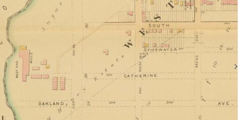
West End Mill as shown on an 1886 West Philadelphia property map.

Note: South Street appears on this map in a place that may surprise readers familiar with the famous street that connects the Schuylkill and Delaware rivers. South Street’s westward extension along the city grid devised by William Penn was interrupted by the Schuylkill, the University of Pennsylvania, and the Woodlands Cemetery. Around the turn of the 20th century, city planners revived Penn’s original name for South Street (Cedar Street) and applied it to the street’s extension from 45th (at the latter’s diagonal intersection with Baltimore Avenue) and 63rd streets. See “South Street (Philadelphia),” Wikipedia.org. A similar logic appears to explain the renaming of South Philadelphia’s Fitzwater Street as Walton Avenue in West Philadelphia.  

This Google Map aerial image shows the approximate location of woods and developed properties on land that was once the Woodside Amusement Park. In its 1950 photo information, the Philadelphia Evening Bulletin listed Woodside Park’s address as Monument and Ford roads. 

The Fairmount Park Trolley Line, built and operated privately by the Fairmount Park Transit Company, carried passengers to Woodside Park, among other destinations in Fairmount Park West. This excerpt from a 1944 Philadelphia Transportation Company Map shows Woodside Park near the intersection of Ford and Monument roads, with the Belmont Reservoir in view on the map. The Woodside Station foregrounds the amusement park. The Fairmount Park Trolley operated here until 1946, when the line ceased operation and was dismantled. 

Pages